Where is Tanner's Peak?

Do you recognize this Place?
Tanner’s Peak is the name of this beautiful little mountain, located within Herriman, Utah, in the southwest corner of Salt Lake County. Tanner’s Peak, creates the southern border for Herriman and is part of the "South Mountain" range. A small range of mountains stretching to the east and west. South Mountain borders the south end of the Salt Lake Valley, and creates more or less the southern border for three cities: Draper, Bluffdale and Herriman.
The northern face of Tanner’s Peak is located directly south of W&M Butterfield Park in Herriman.

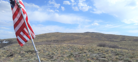
Many Herriman residents have climbed the northern ridge of Tanner’s Peak, finding a familiar lookout point, known as Herriman Flag. The flag is located approximately 6,300 feet above sea level.
The view of the valley below is well worth the hike! The flag pole needs help, and leaves one wanting to take up a collection and install a structure worthy of the ascent.
Looking south from Herriman Flag the elevation continues rising to the southwest with each ridge climbing towards the highest point of Tanner’s Peak.
A huge, toppled watch tower is located near the summit. From this view at the top of Tanner’s Peak looking north, the mountain ridge descends to the northeast.

What is the best route for climbing Tanner’s Peak?
There are a few ways to make the ascent. Here is the easiest route to arrive at Herriman Flag.
The best place to start the hike is the top of Friendship Drive. Elevation at the trailhead is 5,260 feet. The hike to the flag takes about 45 minutes.

Blue signs mark the Trailhead:

Follow the trail southbound for about 400 paces, reach the Diamondback sign. Go left, heading south..
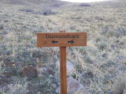
A little further up the trail, arrive at the Diamondback/Sidewinder sign. Go right, heading in a southwest direction..

Turn right at the Bonneville Shoreline Trail sign and follow the trail around the ridge heading northwest..

While heading west and climbing over the ridge line, depart from the trail upon reaching the Carins and begin heading south up the ridgeline..

Some parts get a little steep. Enjoy climbing Tanner’s Peak, especially the view from Herriman Flag.
For good luck, don't forget to give the cross a kiss, as you pass by.
After passing the cross and before you reach the Herriman Flag to the east, your hike will take you across the tire tracks.. if you follow these tracks southbound, you will arrive near the peak and the fallen watch tower.

The elevation at the highest part of Tanner’s Peak is 6,800. Walking from Herriman Flag to the watchtower, takes about 40 minutes.
Tanner’s Peak from Dansie Flats:

A camel's back, known as "Step Mountain" is lurking to the west of Tanner's Peak:

Tanner's Peak from Rosecrest Park:

Comments
Post a Comment